
|
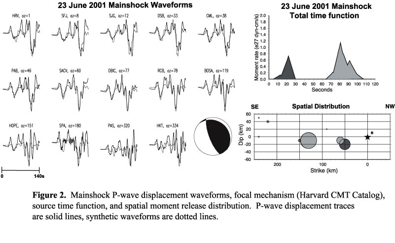
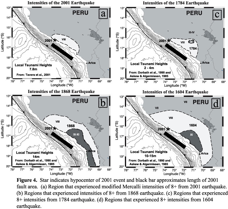
Back The June 23, 2001 Peru Earthquake and the Southern Peru Subduction Zone Melissa K. Giovanni* (giovanni@geo.arizona.edu), Susan Beck (beck@geo.arizona.edu), Lara Wagner (lwagner@geo.arizona.edu) Southern Arizona Seismological Observatory, Dept. of Geosciences, University of Arizona, Tucson, AZ, United States *Now at University of California, Los Angeles (giovanni@ess.ucla.edu) The plate boundary between the South American plate and the subducting Nazca plate along the Peru coast has been the site of large destructive earthquakes for many centuries, including the recent June 23, 2001 (Mw = 8.4) event. This underthrusting event has an aftershock area of 320 km by 100 km based on relocated aftershocks recorded globally during the first month. Modeling of the teleseismic broadband P waveforms of the 2001 Peru earthquake indicate the source time function has two pulses of moment release with the larger second pulse located approximately 120 to 160 km southeast of the mainshock hypocenter indicating a unilateral rupture to the southeast. The south-central Peru segment (12-19 degrees S) of the subduction zone has ruptured in underthrusting earthquakes this century from north to south in 1974 (Mw = 8.0), 1996 (Mw = 7.7), 1942 (Mw = 7.9-8.2) and 2001 (Mw = 8.4). The 1974, 1996, 1942, and 2001 earthquakes have source durations of 60, 45, 75, and 100 seconds respectively, and all initiated with a small pulse of moment release followed by a much larger moment release delayed in time. The 1974, 1996, and 2001 earthquakes all show unilateral rupture to the SSE with the largest pulse of moment release occurring at least 100 km from the mainshock hypocenter. The maximum intensities observed for the 1942 earthquake also suggest a possible southeast rupture. There is some overlap along strike in the aftershock areas of these four events but there does not seem to be overlap in the rupture of the largest asperities associated with each event. Previous earthquakes in 1868, 1784, and 1604 ruptured the same segment of the plate boundary as the 2001 earthquake. Based on intensity and tsunami reports the 1868 and 1604 events were larger than the 2001 earthquake while the 1784 event may have been smaller. Assuming the last earthquake to rupture the southern Peru segment was 1896 then the time between events (133 years) and a convergent rate of 9 cm/yr suggests 12 meters of accumulated tectonic slip prior to the 2001 earthquake. Preliminary estimates of the slip during the rupture of the largest asperity during the 2001 earthquake are 9 to 15 meters, suggesting that a portion of the plate boundary was locked between events. The occurrence of the 2001 earthquake provides further evidence that the mode and size of earthquake rupture along the Peru coast has changed between successive earthquake cycles. |