
In 1986, the Swiss National Science Foundation started an extensive project called NRP 20. The purpose was to study the deep structures of the Alps using a number of crustal scale seismic lines shot across the mountain belt (Fig. 1). The nappe structures yielded excellent reflections, particulary in the internal part of the mountain belt where basement and sedimentary contacts were easily imaged. (Fig. 2). Due to the high quality of the reflection data and the well known surface geology, interpretations could be made down to 15 km depth (Fig. 3).
Figure 1
Tectonic map of the Western Alps, with locations of the deep seismic lines from the Swiss NRP 20 project and from the French ECORS and the Italian CROP projects.
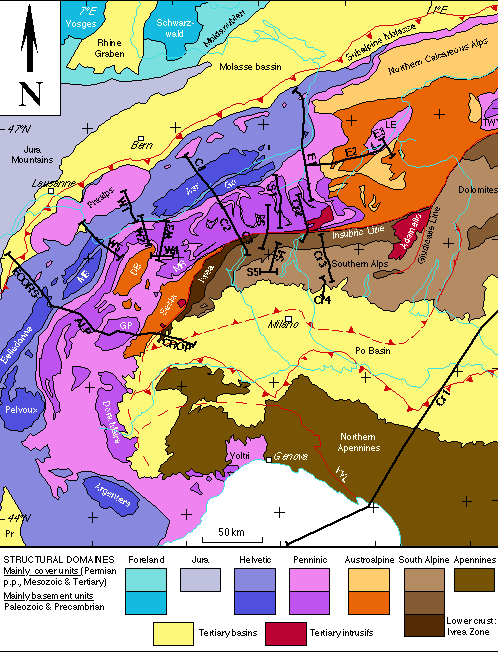
from Marchant, 1993
Figure 2
The NRP20-W3 Vibroseis line yielded an excellent image of the Penninic nappes down to 15 km depth.

from Marchant, 1993
Figure 3
Interpretation of the NRP20-W3 seismic line. Approximately from bottom to top, one can see units from the originating European plate, the Valais suture, the Brianconnais terrain, the Piemont suture, and the Austroalpine terrain.

from Marchant, 1993
Dynamite data provided better imaging of the middle and lower crust and allowed for an interpretation down to the Moho. The following interpretations reveal the importance of backfolding that affects the internal part of the Alps. In Figure 4, the geometry of the Adriatic Moho nearly reaches the surface close to the Insubric Line. Towards the east, this geometry changes as the Adriatic Moho plunges to depth below the Insubric Line (Marchant, 1993).
Figure 4
Crustal scale interpretation of the NRP20 Western traverse. Color coding: blue = European plate, green = Valais suture, mauve = Brianconnais terrain, orange = Austroalpine terrain, brown = Adriatic microplate, yellow = Tertiary basins, red = Tertiary intrusions (Marchant, 1993).
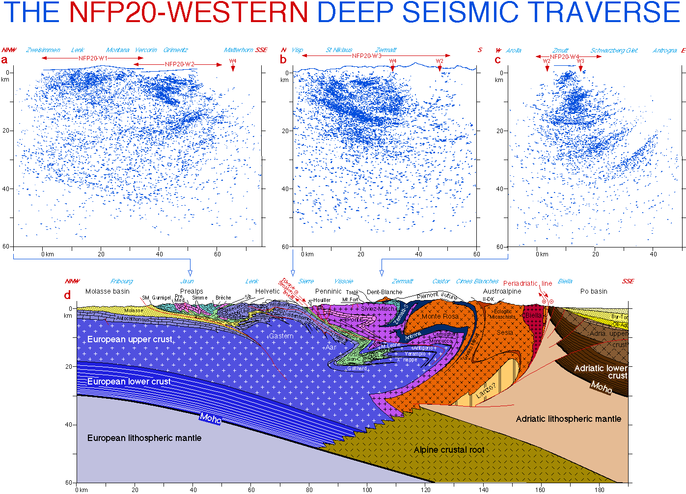
from Marchant, 1993
Tomographic images are able to give a good idea of the lithospheric configurations under the Alps. The interpretation in Figure 5 shows the subduction of the European lithosphere under the Adriatic plate. The positive velocity anomalies (B1 & B2) correspond to cold bodies and are interpreted as the remnants of the Valais and Piemont oceanic lithospheres (Spakman et al., 1993). Gravity data also support this interpretation (Figure 6).
Figure 5
Tomographic cross section along the NRP20 Western traverse. a)Location map. b)Tomographic cross section. c) Interpretation
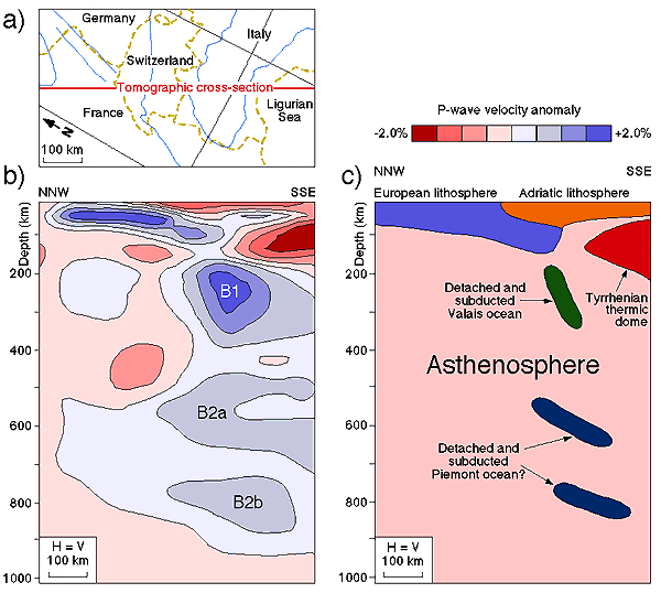
from Spakman et al., 1993
Figure 6
Gravity model along the NRP20 Western traverse, showing the subduction of the European lithosphere under the Adriatic plate. The roots of the European plate show an increasing density with depth due to eclogitisation. The strong positive anomaly near the Insubric line, called the Ivrea anomaly, is mainly due to Adriatic mantle which nearly reaches the surface. Some smaller anomalies can be related to ophiolites of the Valais and Piemont oceans (Marchant, 1993).
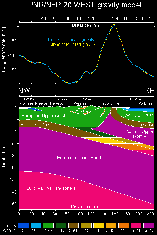
from Marchant, 1993
Putting together the seismic, tomographic, and gravity interpretations yields a lithospheric-scale cross section (Fig. 7).
Figure 7
Lithospheric-scale interpretation along the NRP20 Western traverse, showing the subduction of the European plate under the Adriatic lithosphere. The detached slab probably broke off in the Eocene (Marchant, 1993).
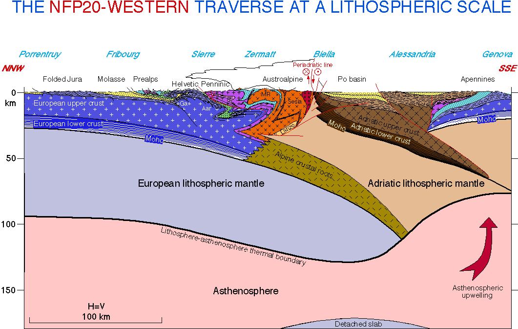
from Marchant, 1993
[ Alpine Overview | Geology |
Geophysics | Geodynamics | Tectonic History |
References ]